


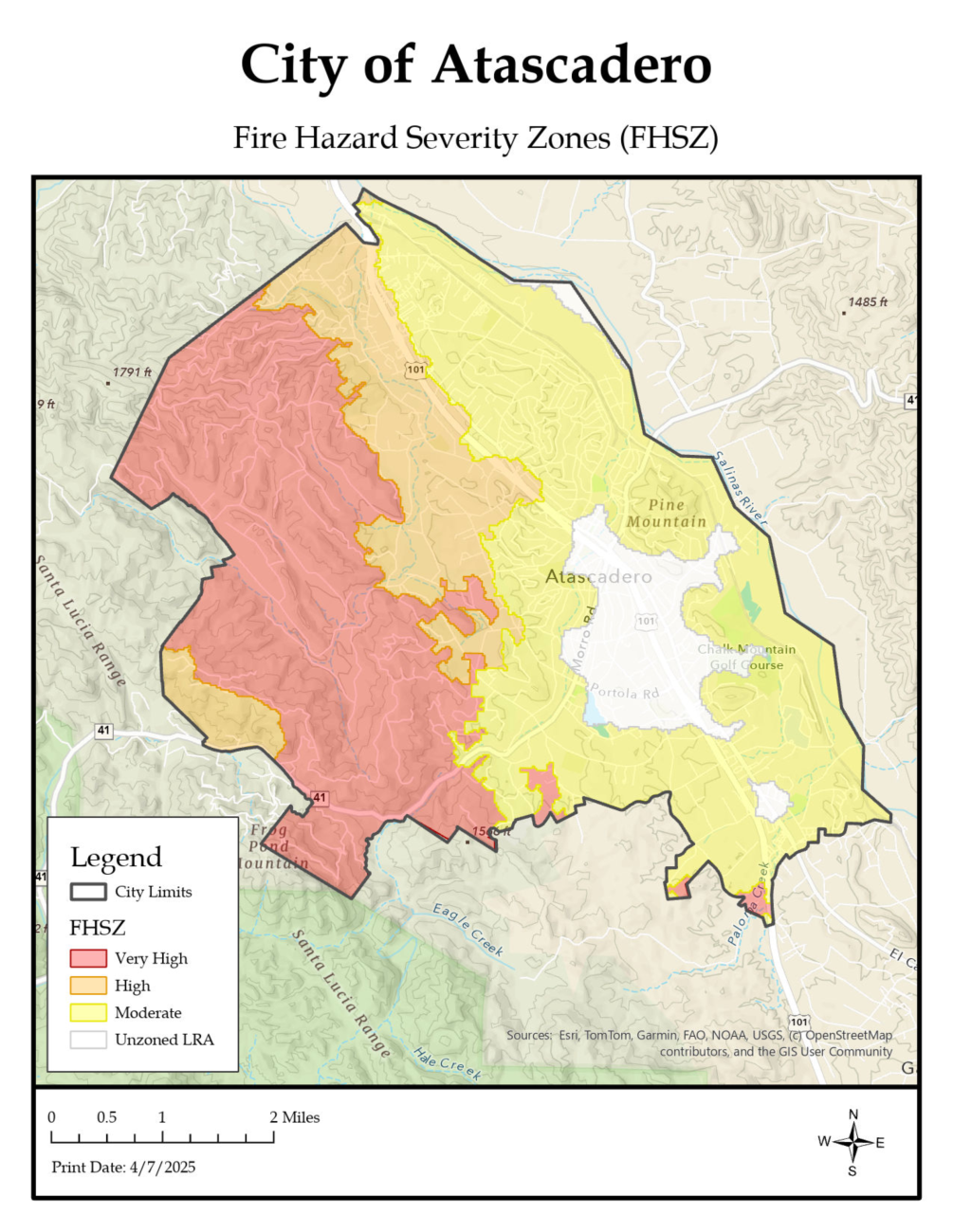
Fire Hazard Severity Zone Map
The recent updates to Fire Hazard Severity Zones (FHSZ) in California provide a more accurate assessment of wildfire risks by incorporating modern climate data and advanced fire modeling. These updates consider factors such as ember cast, vegetation type, slope, and extreme fire weather conditions, among others. The updated maps apply to both State Responsibility Areas (SRA) and Local Responsibility Areas (LRA), impacting fire prevention strategies, building codes, and real estate disclosure obligations. Adoption of these new maps is required by CA Government Code 51179.
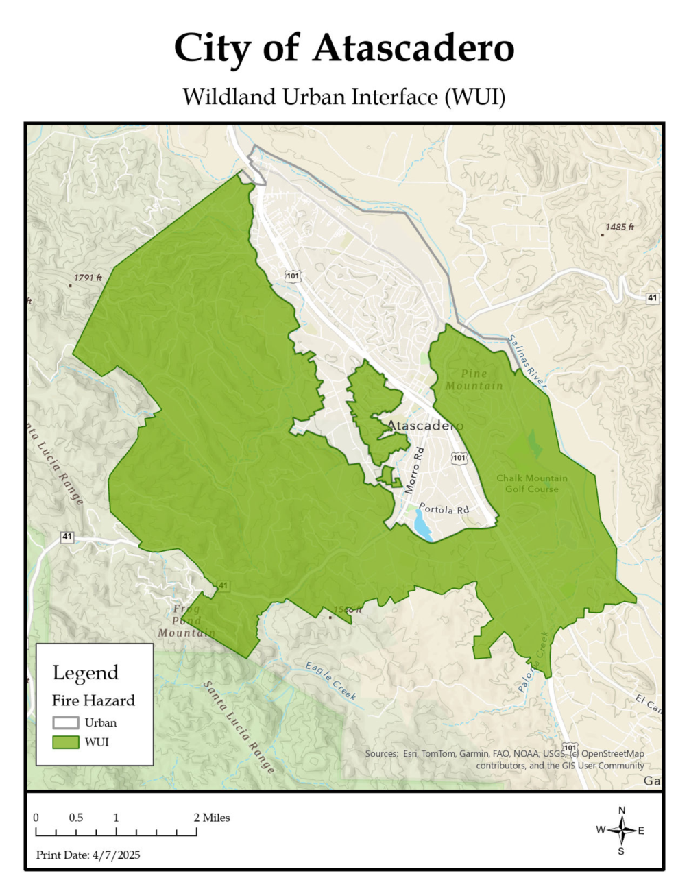
In 2021, the Atascadero City Council adopted a locally developed Wildland Urban Interface (WUI) Zone map. This map incorporates all Very High Fire Hazard Severity Zones from 2011, as well as the Very High and High zones from the previous map. It has since been used as the basis for applying the WUI Building Code to a significant portion of the city.
The Wildland Urban Interface (WUI) Building Code is based on Chapter 7A of the 2022 California Building Code and Section R327 of the 2022 California Residential Code. It establishes requirements for the building materials, systems, and assemblies used in the exterior design and construction of new buildings located within the High or Very High Fire Hazard Severity Zones in the City of Atascadero, as identified on the 2021 Adopted WUI Map. These requirements are detailed in the Fire Severity Zone Special Construction Requirements.
Key Takeaways:
- FHSZ Classification: Properties are categorized as Moderate, High, or Very High Fire Hazard Severity Zones based on terrain, vegetation, fire history, and climate conditions.
- Fire Hazard vs. Risk: The maps indicate hazard potential, not immediate risk, and do not account for mitigation efforts like defensible space or fire-resistant construction.
- Impact on Property Owners:
- Homeowners in Very High FHSZ must comply with stringent defensible space and home hardening requirements.
- 100-foot defensible space clearance is mandatory around structures in these zones.
- New construction and renovations in designated zones must adhere to Wildland-Urban Interface (WUI) building codes.
- Property sellers must disclose FHSZ designations during real estate transactions.
Legislative Updates:
- California Government Code Section 51178 requires the State Fire Marshal to designate areas as moderate, high, or very high fire hazard severity zones using consistent statewide criteria based on factors such as fuel loading, slope, fire weather, and wind conditions.
- California Government Code Section 51178.5 requires local agencies to make newly identified fire hazard severity zones publicly available for review and comment within 30 days of receiving the information from the State Fire Marshal, using clear and accessible formats such as maps.
- California Government Code Section 51179 requires local agencies to adopt fire hazard severity zone designations by ordinance within 120 days of receiving recommendations from the State Fire Marshal, allows them to increase—but not decrease—zone severity levels based on local findings, and mandates public notice, ordinance submission, and map posting requirements to ensure transparency and compliance.
- California Code of Regulations § 1280.02 requires local agencies to submit a PDF copy of any ordinance and map designating Very High Fire Hazard Severity Zones (VHFHSZ) within 30 days of adoption to the Board of Forestry and Fire Protection, along with detailed supporting information, and to provide additional map formats if requested for clarity.
Mapping & Compliance:
- The State Fire Marshal is responsible for updating FHSZ maps, which are used to enforce fire safety standards across the state.
- Residents can check their property's FHSZ status online at osfm.fire.ca.gov/FHSZ.
- Local jurisdictions are required to review and adopt the updated maps, ensuring communities are better prepared for wildfire threats.